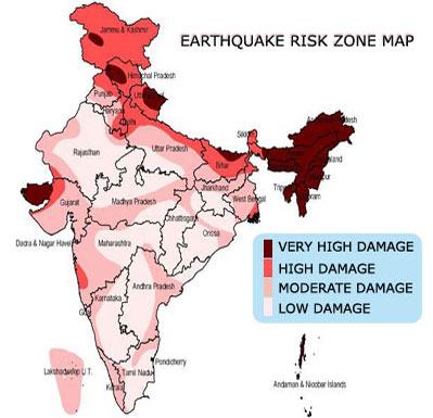
 Earthquake – prone areas of the country have been identified on the basis of scientific inputs relating to seismicity, earthquakes occurred in the past and tectonic setup of the region. Based on these inputs, Bureau of Indian Standards [IS 1893 (Part I):2002], has grouped the country into four seismic zones, viz. Zone II, III, IV and V. Of these, Zone V is seismically the most active region, while zone II is the least. Broadly, Zone – V comprises entire northeastern India, parts of Jammu and Kashmir, Himachal Pradesh, Uttaranchal, Rann of Kutch in Gujarat, part of North Bihar and Andaman & Nicobar Islands. Zone – IV covers remaining parts of Jammu and Kashmir and Himachal Pradesh, National Capital Territory (NCT) of Delhi, Sikkim, Northern Parts of Uttar Pradesh, Bihar and West Bengal, parts of Gujarat and small portions of Maharashtra near the west coast and Rajasthan. Zone – III comprises Kerala, Goa, Lakshadweep islands, remaining parts of Uttar Pradesh, Gujarat and West Bengal, Parts of Punjab, Rajasthan, Madhya Pradesh, Bihar, Jharkhand, Chhattisgarh, Maharashtra, Orissa, Andhra Pradesh, Tamilnadu and Karnataka. Zone – II covers remaining parts of country.
National Centre of Seismology (NCS) has installed a number of Seismic and Global Positioning System (GPS) stations across major faults to monitor the seismicity and crustal movement of the Indian subcontinent.
NCS maintains a National Seismological Network (NSN) for real time monitoring of earthquake activities in and around the country. The NSN now consists of 84 state-of-art digital broadband seismograph stations with VSAT commutations facilities for real time monitoring and auto location of earthquakes in and around the country. This system has latest tools for dissemination of earthquake information to the concerned disaster management authorities and other user agencies in least possible time (8-10minutes) for relief and rescue operations in hour of need.
Under the Koyna Deep Borehole programme, studies have been initiated to carry out scientific investigations for deep borehole drilling in the Koyna-Warna region. The investigations include, Seismological, Geophysical (seismic, gravity, magnetic), LIDAR, geomorphology and structural geological studies, apart from a few exploratory boreholes.
Change of ground water table and other anthropological activities and their influence on earthquake occurrence, have been studied in various regions of the world including Indian region. This process may only trigger an earthquake but it may not cause an earthquake on a fault. Thus, in any case, the main cause of earthquake occurrence is tectonic forces.
National Disaster Management Authority (NDMA), Ministry of Home Affairs (MHA), Ministry of Earth Sciences and other state Disaster Management Authorities, have taken up various initiatives to educate and enhance awareness amongst general public and school children on the general
aspects of earthquakes, their impacts and measures to mitigate losses caused by them.
A National Disaster Response Force (NDRF) is also functional under the general superintendence, direction and control of the NDMA for the purpose of specialized response to natural and man-made disasters. Markets, schools, hospitals and Railway and Bus stations, airports etc. are regularly sensitized by organising mock drills and information dissemination relating to evacuation and steps to be taken during rescue and relief operations.